This Mount Washington Observatory Deck weather webcam takes you to the highest peak in the northeastern part of the United States, Mount Washington, which is located in the state of New Hampshire.
View the rapidly changing weather and scenery from a private weather station at the top of Mount Washington Observatory tower in real time.
The elevation of this White Mountains peak is 6,288.2 feet (1,916.6 metres). It is a well-known hiking destination, but expect a challenging hike in addition to erratic weather. Among the trails nearby are the Tuckerman Ravine Trail, the Jewel Trail, and the Appalachian Trail.
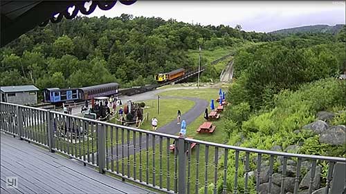
The Mount Washington Cog Railway, which uses both historic steam and biodiesel locomotives, is an excellent way to take a scenic trip to this peak. There is also a toll road to reach this high point, the Mount Washington Auto Road, which extends 7.6 miles (12.2 kilometres), with a median gradient of about 11.6%, from 1,527 feet (465 metres) at the bottom to the altitude of 6,145 feet (1,873 metres).
Please see the map further down the page to locate this tourist destination in New Hampshire, USA.